
Beyond the Weather App: Why Cities Need Street-Level Climate Data
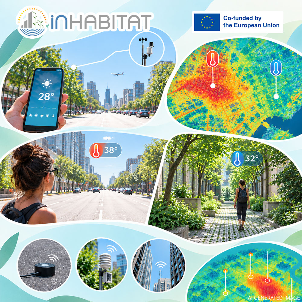
Check the temperature on your smartphone right now.
That number looks exact, but it is almost certainly measured at an official meteorological station located on an open airfield or regional park miles away from your street. Under World Meteorological Organisation guidelines, regional stations are placed in open areas specifically to avoid the thermal influence of buildings and asphalt.
Walk out onto a four-lane city boulevard at 2:00 PM, and your body is experiencing a completely different climate. Dark asphalt absorbs solar radiation, glass facades reflect heat, and dense vehicle traffic also impacts air movement and can restrict ventilation. A street canyon can easily be six to ten degrees hotter than the airport reading. Walk another three minutes into a narrow courtyard with trees and permeable pavers, and the temperature drops again.
Cities are not uniform climate zones. They are complex mosaics of microclimates.
Yet, public climate adaptation plans frequently rely on regional averages. That disconnect is why the INHABITAT Project offers students digital learning modules dedicated to environmental IoT sensing, urban microclimate mapping, and climate-resilient engineering.
Why Regional Averages Fail Urban Planners
During severe summer heatwaves, the urban heat island effect is a major public health hazard. Concrete and asphalt soak up heat during the day and radiate it back out all night, leaving residents without biological recovery time.
When city planners rely only on regional meteorological averages, they often guess where interventions are needed most:
- Installing decorative greenery in areas that already benefit from open airflow while ignoring concrete transit hubs.
- Planting trees that lack root-space or water access, leaving them unable to provide effective canopy shade.
- Designing high-density building blocks without calculating how they trap heat and block cooling evening breezes.
To protect vulnerable residents and lower energy consumption from air conditioning, municipalities need continuous, street-level data.
How Environmental IoT Sensors Change the Game
Through the INHABITAT e-learning platform, the INHABITAT Project offers courses such as Data Acquisition and IoT, Remote Sensing and Geodata Management, and Urban Sustainability, exploring how smart technologies can support more sustainable cities.
These courses introduce environmental sensors that monitor temperature, humidity, precipitation, and air pollution, alongside wireless sensor networks and data visualisation tools. By combining these technologies, engineers and urban planners can gain valuable insights into urban conditions and make more informed decisions about sustainable urban development.
Turning Sensor Data into Liveable Streets
Collecting data is only the first step. The goal of modern smart city training is knowing what to do with that data.
When local authorities see that a specific school crossing or transit stop is consistently baking under extreme surface temperatures, they can target their budgets effectively.
Instead of speculative landscaping, they can replace dark asphalt with reflective or porous surfaces, install active shading, and direct runoff water to support tree growth where it is needed most.
Connecting hardware engineering, environmental data, and municipal planning is the core focus of the INHABITAT Project Master of Science programme. Supported by Erasmus+, the initiative prepares engineers to design cities that remain liveable in a warming climate.
Sources & Further Reading
- INHABITAT e-Learning Platform: https://inhabitat.ea.consulting/
- European Environment Agency (EEA): Urban Adaptation in Europe and Heat Island Exposure: https://www.eea.europa.eu/
- Copernicus Climate Change Service (C3S): Urban Climate Data & Heat Stress Indicators: https://climate.copernicus.eu/
- World Meteorological Organisation (WMO): Guide to Meteorological Instruments and Methods of Observation: https://community.wmo.int/site/knowledge-hub/programmes-and-initiatives/instruments-and-methods-of-observation-programme-imop/guide-instruments-and-methods-of-observation-wmo-no-8-0
Official Website of the Erasmus+ Project INHABITAT: https://www.inhabitatmsc.eu/
Consortium Partners:
- Diethnes Panepistimio Ellados (IHU)
- Politecnico di Milano (POLIMI)
- Kauno Technologijos Universitetas (KTU)
- Hochschule Rhein-Waal (HSRW)
- Cerca Trova (CT)
- Ventspils Tehnikums (VVS)
- ECQA GmbH (ECQA)
- Evolutionary Archetypes Consulting SL (EAC)
- SYSWIN Solutions Srl (SYS)
- Efesto (EF)
- InterConsult Bulgaria (ICB)
- Holonix Srl (HX)
Funding Agency: EACEA – European Education and Culture Executive Agency
101108631 — INHABITAT — ERASMUS-EDU-2022-PI-ALL-INNO
Disclaimer: Funded by the European Union. Views and opinions expressed are however those of the author(s) only and do not necessarily reflect those of the European Union or the European Education and Culture Executive Agency (EACEA). Neither the European Union nor EACEA can be held responsible for them.